


Mobile Topographer Free


Descrizione di Mobile Topographer Free
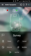
Your mobile Topographer!
The leading tool for the professional surveyor or anyone who wants to mark his property, offering the best accuracy and extensive functionality that no other app can!
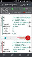
*** Increase GPS accuracy using:
- Weighted averaging (on every axis).
- Map calibration.
- Device calibration on map, or on a know point.
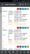
*** Display and convert GPS geodetic to Cartesian EN coordinates and back:
- UTM.
- Europe ETRS89/UTMZ28-38.
- Hellas HGRS 87 (EGSA 87).
- Hellas HGRS 87 - HEPOS.
- Hellas HTRS07/TM07.
- Iceland ISN93/Lambert 93.
- Morocco Merchich.
- SPCS83 (124 zones) USA.
- Romania S-42(58)/Stereo 70.
- Lebanon & Syria Deir ez Zor/Stereo.
- Croatia HTRS96/TM.
- Serbia SRB-ETRS89/UTM, SRB-MGI/Z7.
- Australia MGA94 (GDA94), AMG66 (AGD66) National, A.C.T., Northern Territory, NSW & Victoria, Tasmania,AMG84 (AGD84).
- Former FR of Yugoslavia MGI Balkans zones 5,6 & 7.
- Italy Monte Mario West Zone 1 Peninsular, West Zone 1 Sardinia, East Zone 2 Peninsular, East Zone 2 Sicily.
- Costa Rica CΜ05/CRTM05, Ocotepeque 1935 Costa Rica Norte & Ocotepeque 1935 Costa Rica Sur.
- Cyprus CGRS-93-LTM.
- Hungary HD72/EOV.
- Kosovo KosovaREF01.
- Latvia LKS92/TM.
- Lithuania LKS94/TM.
- Spain ED50/UTMZ29-30 NW, ED50/UTMZ29-31 ML & ED50/UTMZ31 BA.
- Uk's OSTN02/OSGM02.
- Turkey ED50/Gauss-Kruger 3° Z9-15, ITRF96 & ED50/UTMZ35-38.
- Luxembourg LUREF.
- Venezuala REGVEN/Z18-20.
- Sweden SWEREF99 TM.
- Argentina POSGAR 94 & POSGAR 2007.
- India Kalianpur 1975 ZI - ZIV.
- Algeria Nord Sahara 1959 / Z29-32.
- Armenia, Georgia, Azerbaijan, Estonia, Latvia, Lithuania, Russia - Kaliningrad and Kazakhstan Pulkovo 1942/ CS63 (A)Z1-4, (C)Z0-2, (K)Z2-4.
- Central and South America SIRGAS 2000.
- Nigeria and Cameroon Minna 1996 & 2008 MTM West, Mid, East Belts & UTM Z31-33.
- Bangladesh Gulshan 303/TM.
- France RGF93/CC42-50.
- Canada CSRS
- Egypt 1907 Blue, Red, Purple, Extended Purple belts.
- Portugal ETRS89/PTM06.
- Netherlands Amersfoort/RD new.
- Qatar QND95.
- Colombia MAGNA-SIRGAS Far West, West, Bogota, Central East, East zones.
- Mexico ITRF 2008/LCC.
- Madagascar Tananariva (Paris)/Laborde & Tananariva/UTM Z38-39S .
- Tunisia Carthage (Paris)/Mining Grid, Carthage/Nord, Carthage/Sud, Carthage/TM 11 NE, Carthage/UTM zone 32N.
- Liechtenstein CH1903/LV03C-G.
- Switzerland CH1903/LV03 (old), CH1903+/LV95 (new).
- Brazil SAD69/UTM Z18-25 & SAD69(96)/UTM Z18-25
- Spain Canary Islands REGCAN95/LAEA & REGCAN95/LCC & REGCAN95/UTM Z27-28
*** Auto stop for accurate positioning.
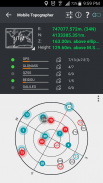
*** Examine the satellites above you in a sky view.
*** Signal strength and number of satellites indication for each GNSS constellation individually.
*** Multiple units support:
- Meters,
- International feet,
- US survey feet.
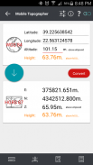
***Height calculation:
- Ellipsoidal height.
- EGM96 orthometric height calculation.
*** Convert from geodetic to Cartesian coordinates and back:
- Support for device measured points, or
- Manually input of geodetic or Cartesian coords.
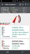
*** Drive me:
- Key in coordinates of the target point in either geodetic or Cartesian coordinates, or select a point from the list and follow the pointer.
- Compass indicating both magnetic and true North.
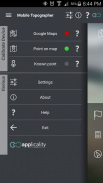
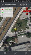
*** Project on Map:
- Project individual points on any map application.
- Project list of points, and the defined polygon, on embedded maps.
*** Save multiple point lists, to use them later.
*** Calculate area.
*** Export point lists το:
- .txt (text file)
- .csv (point file - comma separated)
- .kml (google earth file)
- .gpx (Gps Exchange format)
- .dxf (drawing file)
*** Send file via e-mail, or upload it to cloud.
*** Complete help text support.
Help us improve Mobile Topographer by e-mailing your comments and suggestions.
TAGS: Survey Surveyor Property GPS GNSS GLONASS QZSS BEIDOU GALILEO
Il telefono topografo!
Lo strumento più importante per il geometra professionista o chi vuole marcare la sua proprietà, che offre la migliore accuratezza e funzionalità estese che nessun altra applicazione può!
*** Precisione del GPS Aumenta utilizzando:
- Media ponderata (su ogni asse).
- Calibrazione Mappa.
- Calibrazione del dispositivo sulla mappa o su un punto sapere.
*** Visualizzazione e convertire geodetica GPS per cartesiano EN coordinate e ritorno:
- UTM.
- Europe ETRS89 / UTMZ28-38.
- Hellas HGRS 87 (EGSA 87).
- Hellas HGRS 87 - HEPOS.
- Hellas HTRS07 / TM07.
- Islanda ISN93 / Lambert 93.
- Marocco Merchich.
- SPCS83 (124 zone) Stati Uniti d'America.
- Romania S-42 (58) / stereo 70.
- Libano e Siria Deir ez Zor / Stereo.
- Croazia HTRS96 / TM.
- Serbia SRB-ETRS89 / UTM, SRB-MGI / Z7.
- Australia MGA94 (GDA94), AMG66 (AGD66) nazionale, A.C.T., Territorio del Nord, NSW e Victoria, Tasmania, AMG84 (AGD84).
- L'ex federale di Jugoslavia MGI Balcani zone 5,6 e 7.
- Italia Monte Mario Zona Ovest 1 peninsulare, zona ovest 1 Sardegna, Zona Est 2 peninsulare, Zona Est 2 Sicilia.
- Costa Rica CΜ05 / CRTM05, Ocotepeque 1935 Costa Rica Norte e Ocotepeque 1935 Costa Rica Sur.
- Cipro CGRS-93-LTM.
- Ungheria HD72 / EOV.
- Kosovo KosovaREF01.
- Lettonia LKS92 / TM.
- Lituania LKS94 / TM.
- Spagna ED50 / UTMZ29-30 NW, ED50 / UTMZ29-31 ML e ED50 / UTMZ31 BA.
- Di Uk OSTN02 / OSGM02.
- Turchia ED50 / Gauss-Kruger 3 ° Z9-15, ITRF96 e ED50 / UTMZ35-38.
- Lussemburgo LUREF.
- Venezuala REGVEN / Z18-20.
- Svezia SWEREF99 TM.
- Argentina POSGAR 94 e POSGAR del 2007.
- India Kalianpur 1975 ZI - ZIV.
- Algeria Nord Sahara 1959 / Z29-32.
- Armenia, Georgia, Azerbaijan, Estonia, Lettonia, Lituania, Russia - Kaliningrad e Kazakhstan Pulkovo 1942 / CS63 (A) Z1-4, (C) Z0-2, (K) Z2-4.
- Centro e Sud America SIRGAS 2000.
- Nigeria e Camerun Minna 1996 e 2008 MTM Ovest, media, Cinture Oriente e UTM Z31-33.
- Bangladesh Gulshan 303 / TM.
- Francia RGF93 / CC42-50.
- CSRS Canada
- Egitto 1907 blu, rosso, viola, estesa cinture viola.
- Portogallo ETRS89 / PTM06.
- Paesi Bassi Amersfoort / RD nuovo.
- Qatar QND95.
- Colombia MAGNA-SIRGAS Far West, West, Bogota, centro-orientale, le zone orientali.
- Messico ITRF 2008 / LCC.
- Madagascar Tananariva (Parigi) / Laborde & Tananariva / UTM Z38-39S.
- Tunisia Cartagine (Parigi) / Mining griglia, Cartagine / Nord, Cartagine / Sud, Cartagine / TM 11 NE, Cartagine / UTM zona 32N.
- Liechtenstein CH1903 / LV03C-G.
- Svizzera CH1903 / LV03 (vecchio), CH1903 + / MN95 (nuovo).
- Brasile SAD69 / UTM Z18-25 & SAD69 (96) / UTM Z18-25
- Spagna Isole Canarie REGCAN95 / LAEA & REGCAN95 / LCC e REGCAN95 / UTM Z27-28
*** Arresto automatico per il posizionamento preciso.
*** Esaminare i satelliti sopra di voi in una vista del cielo.
*** Potenza del segnale e numero di satelliti indicazione per ogni costellazione GNSS singolarmente.
*** Unità supporto di più:
- Metri,
- piedi internazionali,
- Piedi Survey.
*** Calcolo Altezza:
- Altezza ellissoidale.
- EGM96 calcolo altezza ortometrica.
*** Convertire da geodetica di coordinate cartesiane e ritorno:
- Supporto per il dispositivo misurato punti, o
- Inserire manualmente delle coordinate geodetiche o cartesiane.
*** Guidami:
- Digitare le coordinate del punto di arrivo in coordinate cartesiane sia geodetiche o, o selezionare un punto dall'elenco e seguire il puntatore.
- Bussola che indica sia magnetico e il Nord.
*** Progetto sulla mappa:
- Progetto singoli punti su qualsiasi applicazione mappa.
- Elenco progetti di punti, e il poligono definito, sulle mappe incorporate.
*** Salva più elenchi di punti, da utilizzare in un secondo momento.
*** Calcola zona.
*** Elenchi di punti Export το:
- Txt (file di testo)
- .csv (File di punti - separati da virgola)
- .kml (File Google Earth)
- .gpx (GPS eXchange Format)
- (File di disegno) .dxf
*** Invia file tramite e-mail, o caricarlo su cloud.
*** Supporto completo testo di aiuto.
Aiutaci a migliorare mobile topografo tramite e-mailing vostri commenti e suggerimenti.
TAGS: Indagine Surveyor GPS proprietà GNSS GLONASS QZSS Beidou GALILEO
Mobile Topographer Free - Versione 9.3.2
(22-05-2019)

Mobile Topographer Free - Informazioni APK
Versione APK: 9.3.2Pacchetto: gr.stasta.mobiletopographerUltima versione di Mobile Topographer Free
Altre versioni


App nella stessa categoria

Potrebbe piacerti anche...


